
| Area: | Lake District | Ascent: | 1410 feet |
| Walk No: | 95 (Part 2) | Time: | 3 hours 45 minutes |
| Date: | 6th November 2007 | Parking: | Elterwater |
| Distance: | 6.50 miles | Weather: | Fine and Sunny |
| Route: | Elterwater - Red Bank - Loughrigg Fell - Loughrigg Tarn - Skelwith Bridge - Elterwater |
I was by myself today as Edith was visiting her brother. It was a glorious day but I wanted to be back for mid afternoon so it was a quick dash up the M6 and along the A591 to Ambleside and then to Elterwater. My route was quite simple. From Elterwater I made my way up towards Huntingstile Crag before dropping down to the top of the Red Bank road. From there I nipped up Loughrigg Fell enjoying glorious views every step of the way. After following the ridge southwards I descended to Loughrigg Tarn and then to Skelwith Bridge. From there it was a simple stroll back to Elterwater taking in Skelwith Force on the way.
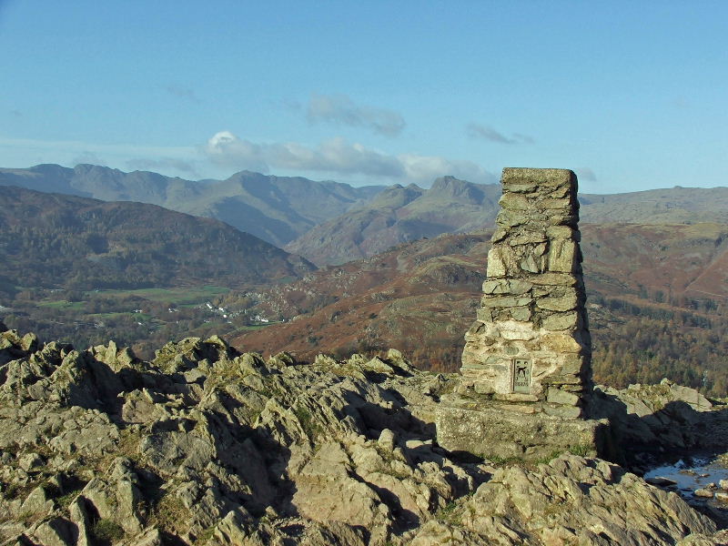
Loughrigg Fell summit

Coniston Old Man, Wetherlam, Swirl How and Great Carrs from Loughrigg

Lingmoor Fell from Loughrigg with Cold Pike, Pike O'Blisco, Crinkle Crags and Bowfell behind.

The Crinkle Crags, Bowfell, Esk Pike, Great End, Loft Crag, Pike O'Stickle, Harrison Stickle and Pavey Ark.

Siver How with The Langdales behind. The "knobble" of Sergeant Man is in the centre

The colour of the ridges and a slight haziness combines the Helm Grag - Calf Crag ridge with Steel Fell behind

Seat Sandal (with Dollywaggon Pike behind), Fairfield, Great Rigg and Heron Pike

In the foreground, Heron Pike and Nab Scar. Behind (l-r) Fairfield, Hart Crag, Dove Crag, High Pike & Low Pike

In mid picture, Red Screes with Froswick and Ill Bell behind

On the far left, Yoke, with Wansfell Pike in the centre

Not very clear as it it's into the sun but this shows my way ahead with Windermere in the distance

Looking up Great Langdale on my descent

As I headed S'ly I met up with a number of walkers coming up from Ambleside

Ambleside with Wansfell Pike behind


My final view from the ridge. From here I would drop down to the path running across the picture and turn right to Loughrigg Tarn

Loosing height didn't mean loosing views however

A new type of gate opener!.....It didn't need adjusting either

Loughrigg Tarn


Walking around the tarn and taking in all the colours


From the tarn it was only a short walk down to Skelwith Bridge where I had a short stop for my banana. I very rarely take butties when walking alone probably because I'm too idle to make them myself

The path to Skelwith Force

Looking down to the Force from the path

and from a little bit closer


If I remember right it is called the Woodburn Bridge. It was erected November 2006 and bypasses the road at Skelwith Bridge for those on the way to Colwith Force

The Langdales from the beckside path to Elterwater


The recently upgraded path to Elterwater

The LDNPA were still working on the finally section at Elterwater so a small diversion through the fields was made

and finally back to Elterwater at the end of a splendid half-day walk
To return to Part 1 of this walk click here
Next Walk: 9th November 2007 - Top o' Selside from High Nibthwaite
We hope you have enjoyed viewing this walk. If you have any comments please sign our Guestbook or E_Mail us
