| Area: | Lake District | Ascent: | 850feet |
| Walk No: | 546 | Time: | 3hours |
| Date: | 31st May 2011 | Parking: | Pelter Bridge car park (free) |
| Distance: | 5.00miles | Weather: | Cloudy with some sunny spells & a couple of light showers |
For those of you that are thinking of going onto the hills I would strongly recommend that you read the advice given by the Mountain Rescue organisation of England and Wales. To read this advice, which will open in a new page please click HERE. If you would like to make a donation to the Mountain Rescue organisation which is purely voluntary please click HERE. Please make the time to read the advice page.
---------------------------------------------------------------
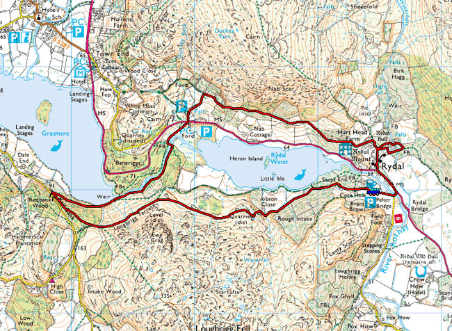
It's Ediths day for visiting her brother so after dropping her off there I made my way to Rydal to park at Pelter Bridge. Actually there wasn't a lot of room left for parking as a maintenance team were using the car park as a storage facility whilst they were doing repairs in the area. This is one of our favourite low level walks in the area although in better times it would have included a circuit of Grasmere as well.

Route Map


Having squeezed into the already crowded car park I made my way up the lane.

Looking along Rydal Water. It isn't the brightest of days and there are showers forecast but hopefully I'll miss them.

A look across to Nab Scar as I make my way along the concessionary path to the old quarries.

Romantically described as a cave the old quarry as been deemed unsafe for a while because of rock falls. It doesn't stop most folk from having a look inside but don't come after me looking for "compo" if you're crushed. ;-)

Loughrigg Terrace....a low level route offering higher level views.

Looking over White Moss Common towards the Easedale Fells.

Nab Scar

As I continued along the terrace route there were some showers coming over Silver How

Nab Scar again as I dig my jacket out of the bag.

Fortunately I only caught the edge of it and within a few minutes it was gone.

There it goes, passing over Seat Sandal and Great Rigg.....

.....leaving me a not too bad view along Grasmere to Dunmail.

Not too bad looking back either!


A bit of a zoom in on Helm Crag and Steel Fell.


As I reached the end of the terrace another shower was approaching. Fortunately the jacket wasn't required this time as I made my way down through the shelter of the woods....

.....to the shores of Grasmere and the sun.

It doesn't look too inviting but just to my left there was a lady (grandmother I presume) with 5 youngsters aged between 2 and 5 who were enjoying a paddle in their undies.

Silver How (l) and Helm Crag (r)

From Grasmere I decided to follow the River Rothay downstream to White Moss.


The path followed the river for a while and then I crossed a footbridge which took me through the car park area to cross the A591 to take a track up to the Grasmere - Rydal Corpse Road.

The falls at the start of the track upwards.

Looking over to Silver How as I reach the Corpse Road.

Loughrigg across the valley.

Looking into the sun to Wansfell as I make my way to Rydal.

Loughrigg over Rydal Water.


I can never resist coming into the grounds of Rydal Hall if in the area...

The gardens are delightful and peaceful and the "Grot" is always worth a peek.


Of course I could have an ulterior motive!

Suitably refreshed all that was left was a short walk back to the car passing by St Mary's Church along the way.
Next Walk: 2nd June 2011 - Lake District - Todd Crag & Loughrigg Tarn from Clappersgate
Last Walk: 30th May 2011 - Lake District - Above the Trout Beck valley from Moor Howe.
Do you have a Facebook or Twitter account? We post regular updates on both plus some additional pictures. Just click on either of the links below and add us.
We hope you have enjoyed viewing this walk. If you have any comments please sign our Guestbook or E_Mail us.